|
| Our Field Ecology Center published more than
180 methodical materials for nature studies. Some of them are in English: |
|
|
|
Mapping Forest Vegetation
© Alexsander S. Bogolyubov,
Nadejda S. Lazareva, Russia, 2001
© Michael J. Brody, USA,
2003
 This manual describes
two procedures for vegetation mapping: complete and transect mapping. The stages of field
studies are described including reconnaissance survey, determination and mapping of plant
associations and geobotanical description of typical vegetation. Related lab studies
include mapping and analysis of the spatial distribution of vegetation. This manual describes
two procedures for vegetation mapping: complete and transect mapping. The stages of field
studies are described including reconnaissance survey, determination and mapping of plant
associations and geobotanical description of typical vegetation. Related lab studies
include mapping and analysis of the spatial distribution of vegetation.
This field study has instructional video
featuring real students conducting the ecological field techniques in nature. Each video
illustrates the primary instructional outcomes and the major steps in accomplishing the
task including reporting the results.
Introduction
The study of ecological interrelationships of any area should result in the
determination of spatial distribution patterns for components of the ecosystems at
the given area, mainly – revealing interrelationships between the vegetation and its
biotope.
As mentioned above, such data can be obtained by two major procedures: by establishing
and describing an integrated landscape profile, and by geobotanical map-making. Procedures
for establishing and describing the profile were discussed in previous lessons in the
autumn field studies course. In this lesson students will learn how to make a geobotanical
map.
Methods and results of vegetation studies by making profiles and by map-making are
similar, though each procedure has its own peculiarities and objectives.
Results of profiling are shown visually in the form of the profile drawing – a
vertical “section” of the site under study (a side view), whereas results of
geobotanical map-making are expressed in the form of a colorful map (an
"aerial" view).
Vegetation studies resulting in a profile can better demonstrate vegetation changes
depending on relief (for instance, along the line “valley-watershed”), whereas
a geobotanical map can better illustrate contours of plant associations, their
diversity and the correlation of different plant associations.
A secondary goal – why we study vegetation – has influence upon the selection of
the method of vegetation representation. When studying vegetative cover, it is advised to
study it by making a profile as it can better show peculiarities of vegetation
distribution and its connection with relief and soils. A complex profile is suggested when
conducting an integrated ecological or special geobotanical study.
When conducting monitoring and zoological investigations, for instance, when studying
pollution or ionizing radiation background, or when studying the nesting areas of birds or
structure of mammal populations, it is recommended to study vegetation by a map-making
method. It is advised to make geobotanical maps when studying other objects if their
distributions depend on vegetation (invertebrates, lichens, fungi, etc.)
Procedures for vegetation mapping
Geobotanical maps as well as other maps are divided according to scale into small-,
middle- and large-scale maps. This lesson will focus on making large-scale geobotanical
maps without discussing the peculiarities of the world’s vegetation and regions or
botanical-geographical regions.
A large-scale geobotanical map gives one an idea about the distribution of plant
associations on a limited site of the area under study; it indicates the nature of
boundaries and changes among them.
A geobotanical map can be made in compliance with different procedures, starting from a
complete geobotanical survey and ending with air or space mapping, however, we will limit
our procedure to two variables for the purposes of the present lesson – complete mapping
of a forest tract with the help of an eye survey method and mapping of a linear transect.
Which procedure should be given preference, depends first of all upon peculiarities of
vegetation of the area under study.
It is advisable to apply a method of complete mapping at scale 1:5000 (50 m in 1
cm) in forested areas with slightly disturbed vegetative cover and more or less
distinct changes in plant associations. The site can have an approximate size of 0.5 X 0.5
km (0.25 km2).
It is recommended to use a procedure of linear transects to study sites with
much patchiness of vegetative cover (parks, forest belts) and in case there is no
map-basis available. A linear transect is a belt of 70-100 meters wide and about 1 km
long.
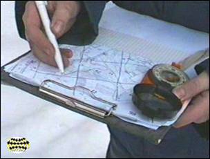
Complete mapping of a forest tract by an eye survey method
Complete mapping by an eye survey method involves walking the mapped site (it is a
forest track, as a rule) along a network of parallel routes with simultaneous
plotting of plant association boundaries on a ready cartographic framework with subsequent
extrapolation of their contours for sections between routes.
Routes are laid down in straight lines parallel to each other at a distance of 50-100
meters from each other, depending on the complexity and patchiness of vegetation cover in
forested areas or very rugged terrains.
While forest mapping, a group of students is divided into teams of 2 pupils. One
team is given the task to map the forest track along the perimeter, whereas all other
teams are...
This was only the first page from the manual and its full version you can see in the
Ecological Field Studies Techniques Video 4CD Set:
It is possible to purchase the complete set of 40 seasonal Ecological Field
Studies Techniques Video (in mpg format) in an attractive 4 compact disk set.
These compact disks are compatible with Mac and PC computers.
The videos are suitable for individual student or whole class instruction. To purchase the complete 4CD set
write to ecosystema1994@yandex.ru in a free form.

Ecological Field Studies Demo Disk:
We also have a free and interesting demonstration disk that explains our ecological field studies approach.
The demo disk has short excerpts from all the seasonal field study videos as well as sample text from all the teacher manuals.
The disk has an entertaining automatic walk through which describes the field study approach and explains how field studies meet education standards.
You can also download the Demo Disc from ecosystema.ru/eng/eftm/CD_Demo.iso.
This is a virtual hybrid (for PC and Mac computers) CD-ROM image (one 563 Mb file "CD_Demo.iso").
You can write this image to the CD and use it in your computer in ordinary way.
You also can use emulator software of virtual CD-ROM drive to play the disk directly from your hard disk.

|


