|
| Our Field Ecology Center published more than
180 methodical materials for nature studies. Some of them are in English: |
|
|
|
Simple Procedure of Soil Description
© Alexsander S. Bogolyubov,
Michael. V. Kravchenko, Sergey V. Baslerov, Russia, 2001
© Michael J. Brody, USA,
2003
 This manual contains a procedure for soil profile construction and its
description according to morphological features. The technique of soil composition
description is based on soil horizons, soil and its horizon thickness, coloring, soil
moisture, mechanical composition, structure and texture, new formations and inclusions. This manual contains a procedure for soil profile construction and its
description according to morphological features. The technique of soil composition
description is based on soil horizons, soil and its horizon thickness, coloring, soil
moisture, mechanical composition, structure and texture, new formations and inclusions.
This field study has instructional video
featuring real students conducting the ecological field techniques in nature. Each video
illustrates the primary instructional outcomes and the major steps in accomplishing the
task including reporting the results.
Introduction
When conducting complex field studies with students, introduction to the soils
of the studied area is an integral part of environmental research as well as environmental
education. Correctly organized soil studies will enable young researchers to understand
the origin and evolution (developmental process) of ecosystems within the area, and even
to assess developmental perspectives of its vegetation, water regime and fauna.
In field conditions, soils are described and identified according to their appearance,
i.e. morphological features. The soil can be identified according to its
morphological features exactly the same way as we identify minerals, plants or animals.
That is why it is especially important to know how to describe soil type, recording
its morphological features in the field.
Based on morphological features, it is possible to judge the direction and the extent
of the soil-forming process and, more specifically, to classify soil types. However, due
to the difficulties of soil classification and, moreover, differences in systems of soil
classification in different countries, this manual does not cover identification
(determination) of soil types.
The goal of this lesson is to introduce students to the soils of their
region by having them identify soil types according to their morphological features. One
of the most important and meaningful parts of this study is not simply the description of
different soil horizons, but an attempt to reveal functional parts in the described
soil.
In this manual we present a general diagram of soil division into functional zones and
corresponding typology of soil horizons. Based on the descriptions according to a unified
procedure presented in the manual, we will be able to identify, classify and compare soils
that are described anywhere on earth.
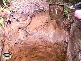
Procedure of soil profile embedding
It is widely accepted in soil science to dig special pits called soil profiles
(test soil pits) in order to describe soil types, study their morphological features,
define boundaries between different soil types and collect samples for analyses. Any soil
study starts not with the digging of a pit but with selection of pit location.
Selection of location of soil profile
In order to choose the right place for the soil profile, the area should be thoroughly
examined in relation to relief and vegetation. If the relief is flat, the pit is excavated
in a central, most representative part. A slope is excavated in its top, middle and bottom
parts. When studying a river valley, pits should be dug in the floodplain (alluvial flat),
terraces and in the watersheds.
When conducting a complex environmental research of an area, soil profiles should be
embedded, one in each main type of plant associations. If it is a lesson, the
profile should be embedded in one, most typical plant association of the region.
The profile should be dug in the most representative place of the studied territory.
They should not be embedded near roads or ditches, or any location untypical for...
This was only the first page from the manual and its full version you can see in the
Ecological Field Studies Techniques Video 4CD Set:
It is possible to purchase the complete set of 40 seasonal Ecological Field
Studies Techniques Video (in mpg format) in an attractive 4 compact disk set.
These compact disks are compatible with Mac and PC computers.
The videos are suitable for individual student or whole class instruction. To purchase the complete 4CD set
write to ecosystema1994@yandex.ru in a free form.

Ecological Field Studies Demo Disk:
We also have a free and interesting demonstration disk that explains our ecological field studies approach.
The demo disk has short excerpts from all the seasonal field study videos as well as sample text from all the teacher manuals.
The disk has an entertaining automatic walk through which describes the field study approach and explains how field studies meet education standards.
You can also download the Demo Disc from ecosystema.ru/eng/eftm/CD_Demo.iso.
This is a virtual hybrid (for PC and Mac computers) CD-ROM image (one 563 Mb file "CD_Demo.iso").
You can write this image to the CD and use it in your computer in ordinary way.
You also can use emulator software of virtual CD-ROM drive to play the disk directly from your hard disk.

|


