|
| Our Field Ecology Center published more than
180 methodical materials for nature studies. Some of them are in English: |
|
|
|
Procedure of the Geological Exposure Description
© Alexsander S. Bogolyubov,
Sergey V. Baslerov, Russia, 1999
© Michael J. Brody, USA,
2003
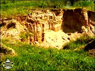 This manual contains a procedure for description and
analysis of geological exposure including: selection of a study site, preparation of the
geological exposure under study, descriptions of the profile for the selected geological
structures and interpretation and presentation of the results. This manual contains a procedure for description and
analysis of geological exposure including: selection of a study site, preparation of the
geological exposure under study, descriptions of the profile for the selected geological
structures and interpretation and presentation of the results.
This field study has instructional video
featuring real students conducting the ecological field techniques in nature. Each video
illustrates the primary instructional outcomes and the major steps in accomplishing the
task including reporting the results.
Introduction
When conducting complex field studies with students, introduction to the geological
structure of the studied area is an integral and important part of ecological
research as well as environmental education. Properly organized geological studies will
enable young researchers to understand the origin and evolution (developmental process) of
ecosystems within the area, and to assess developmental perspectives of its vegetation,
water regime and fauna.
As a result of field geological studies it is possible to characterize structure,
age, conditions of formation and embedding of rocks; features of the relief, connections
of forms and elements of the relief with geological structure; geological processes that
take place now and that took place in the recent past.
The educational task is the study of properties of sedimentation, with stress on
the study of alluvial sediments.
Studying sedimentary rocks and alluvial deposits, one can approximately judge
geological structure of the given area, about conditions of its formation as a whole, and
of each geological horizon separately.
The goal of this educational task is to introduce students to the geological
structure of their region. One of the most important, meaningful (intellectual) parts of
this study is not just detection and description of different geological horizons but also
structure of the landscape relief.
General information on a subject of study
The procedure for studying the geological structure of plain river valleys flowing in loose
sedimentary deposits is considered in this manual. Only in such conditions does the
river have the possibility of free development, forming well-expressed valleys with
sedimentary deposits many meters thick, which can be easily studied. The study of the
geological structure of mountain river valleys is not provided by the given educational
task, as their development is limited with flow-resistant rocks, furthermore, they are
described differently.
Processes that take place in the flow of water determine how the relief
forms of a river valley (floodplains and terraces located above flood lands) were shaped.
These processes cause the river either to branch, forming islands, or to meander, i.e. to
curve, forming ridges of river deposits within the channel (which are usually located from
one peak of the meander to another). In the low-water period, peaks of these ridges can
tower above the water level and can be overgrown with grass. A floodplain is formed by
attachment of these ridges or islands to the bank with their subsequent overlapping with
inundated alluvium.
The geological base of the fluvial plain is laid down by riverbed alluvium,
overlapped by inundation, which is modified by the river during a period of
regular inundation in flooding (caused by snowmelt) and high water (caused by rains). The
floodplain is no longer a floodplain when it is not flooded any more – then it turns
into terrace located above flooded land (further in the text TLF). It
can occur when a river erodes further below the surface of the land, or there is a
decrease in the river flow.
Three types of river alluvium are known: riverbed, inundated and old-channel. It is
necessary to distinguish them, as different types of alluvium are formed under different
conditions and their external shape (appearance) allows us to make conclusions on their
origin.
For example, riverbed alluvium is formed in the channel of a river, under
conditions of high current velocities and large depth. Riverbed alluvium has the largest
sized particles (because they are deposited by a current with large lifting (elevating)
ability, which is determined by water mass and stream velocity). Inundated alluvium
is deposited at the flood plain during floods or high water. The river flow due to small
depth (as a result of wide flood) has low velocity and it is not capable of
transferring...
This was only the first page from the manual and its full version you can see in the
Ecological Field Studies Techniques Video 4CD Set:
It is possible to purchase the complete set of 40 seasonal Ecological Field
Studies Techniques Video (in mpg format) in an attractive 4 compact disk set.
These compact disks are compatible with Mac and PC computers.
The videos are suitable for individual student or whole class instruction. To purchase the complete 4CD set
write to ecosystema1994@yandex.ru in a free form.

Ecological Field Studies Demo Disk:
We also have a free and interesting demonstration disk that explains our ecological field studies approach.
The demo disk has short excerpts from all the seasonal field study videos as well as sample text from all the teacher manuals.
The disk has an entertaining automatic walk through which describes the field study approach and explains how field studies meet education standards.
You can also download the Demo Disc from ecosystema.ru/eng/eftm/CD_Demo.iso.
This is a virtual hybrid (for PC and Mac computers) CD-ROM image (one 563 Mb file "CD_Demo.iso").
You can write this image to the CD and use it in your computer in ordinary way.
You also can use emulator software of virtual CD-ROM drive to play the disk directly from your hard disk.

|


