This page contains the list of images of Kamchatka's volcanoes and
the results of volcanic activity,
made by the participants of the Moscow city school #57 youth
ecological expeditions (2002, 2006 и 2007).
Clicking on the preview in the list below you will be transferred to the
page with full sized image
(usually 1024 x 768 pixels and approximately 150 kilobytes)(open in a new window).
Asia, Russia
VOLCANOES OF KAMCHATKA
(Russian Far East)
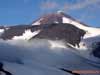
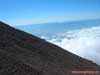
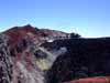
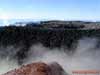
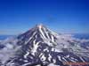
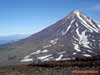
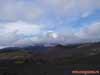
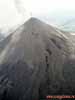
Avachinsky volcano (height 2741 meters): old cone
(somma, or "collar") and new cone (in the distance)
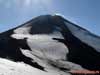
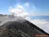
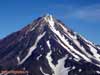
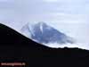
Avachinsky volcano (height 2741 meters).
View to the new cone from the "collar" (somma, or old cone)
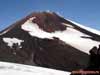
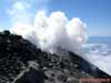
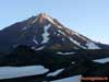
Avachinsky volcano (height 2741 meters).
View to the new cone from the "collar" (somma, or old cone)
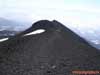
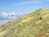
Avachinsky volcano slope. View to the side local cone in the volcano atrio
(depression between the "collar", or somma, or old cone, and new cone
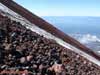
Scoria sediments (pyroclastic material) on the Avachinsky volcano slope
Basalt-andesit extrusion - rock "Alpinist" on the Avachinsky volcano slope
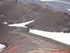
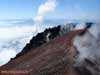
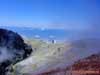
External crater slope of the Avachinsky volcano (altitude - 2650 meters above sea
level)
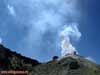
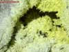
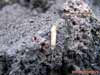
Side fumarole on the external crater slope of the Avachinsky volcano
(altitude - 2650 meters above sea level)
Side fumarole on the external crater slope of the Avachinsky volcano
(altitude - 2650 meters above sea level)
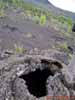
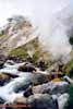
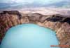
Internal slope of the Avachinsky volcano crater (altitude - 2740 meters above sea
level).
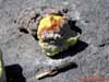
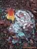
Fumarole chink with volcano sulfur sediments (yellow) and lava stopper (plug)(black)
Internal slope of the Avachinsky volcano crater (altitude - 2740 meters above sea
level).
Fumarole chink with volcano sulfur sediments (yellow) and lava stopper (plug)(black)
Internal slope of the Avachinsky volcano crater (altitude - 2740 meters above sea
level).
Fumarole chink with volcano sulfur sediments (yellow) and lava stopper (plug)(black)
Internal slope of the Avachinsky volcano crater (altitude - 2740 meters above sea
level).
Fumarole chink with volcano sulfur sediments (yellow) and lava stopper (plug)(black)
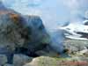
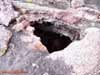
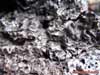
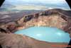
Internal, most deep part of the Avachinsky volcano crater.
Fumarole chink with volcano sulfur sediments (yellow) and lava stopper (black, on the
right)
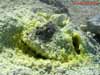
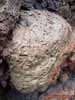
Lava stopper (plug) in the Avachinsky volcano crater.
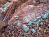
Small fumarole and volcano sulfur sediments on the lava
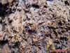
Lava stopper (plug) in the Avachinsky volcano crater.
Small fumarole and volcano sulfur sediments in the lava block basis
Lava stopper (plug) in the Avachinsky volcano crater.
Fumarole and volcano sulfur sediments in the lava block
Internal slope of the Avachinsky volcano crater (altitude - 2740 meters above sea
level).
Fumarole chinks and lava stopper (plug)(right)
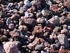
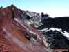
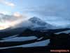
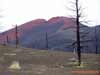
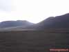
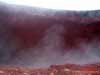
Plosky ("Flat") Tolbachik volcano outskirts. One of the volcano burst
(break) cones,
covered by red scoria sediments (pyroclastic material)
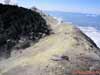
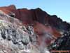
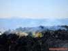
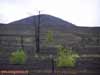
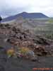
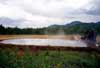
Scoria sediments (pyroclastic material) fields around one of the Plosky
("Flat") Tolbachik volcano.
Dead larch forest, burnt after Great Tolbachik Fissure Eruption (GTFE) in 1975-1976
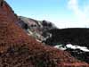
Scoria sediments (pyroclastic material) fields around one of the Plosky
("Flat") Tolbachik volcano.
The result of the Great Tolbachik Fissure Eruption (GTFE) in 1975-1976
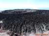
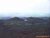
Scoria sediments (pyroclastic material) fields around one of the Plosky
("Flat") Tolbachik volcano.
The result of the Great Tolbachik Fissure Eruption (GTFE) in 1975-1976.
Two new volcano burst (break) cones in the distance
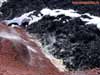
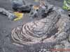
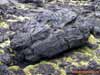
Lava conglomeration after the Great Tolbachik Fissure Eruption (GTFE) in 1975-1976.
Plosky ("Flat") Tolbachik volcano outskirts
Hardened lave stream. Plosky ("Flat") Tolbachik volcano outskirts
From Photo Nature section of our site you can also download thousands images of fungi, lichens, plants and animals, made by professional Russian field biologists and geographers during their expeditions all over the Russia and former USSR republics. All objects from our collection are determined by scientist and have exact scientific name, date and place of taking picture, as well as size of the original image.
You are able to find necessary pictures using four different approach:
1) with a help of Geographic Index (all objects are separated by countries and nature geographical zones), 2) with a help of Systematic Index (all objects are separated by their systematic position),
3) with a help of Alphabetical Index (all objects are separated by their scientific Latin names according to the alphabet), and
4) with a help of Search Form (you can search scientific (Latin) names of species, genus, family, or order).
[an error occurred while processing this directive]