This page contains the list of images of the Altai Mountains nature:
natural landscapes, vegetation types and some plants and animals.
Clicking on the preview in the list below you will be transferred to the page with the
full sized image
(usually 1024 x 768 pixels and approximately 150 kilobytes).
Asia, Russia
ALTAI MOUNTAINS Altai Republic
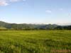
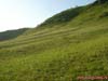
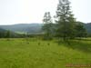
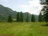
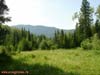
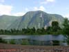
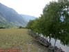
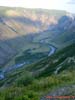
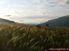
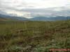
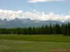
Typical landscape of medium-mountains with grass meadow steppes (foreground) and dark
coniferous forests (away). Height is about 1000 m above sea level. Northwestern Altai,
valley of the Karakol river, Karakol Nature Park "Uch-Enmek", Ongudansky
District, Altai Republic
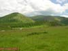
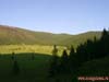
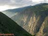
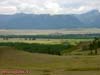
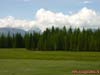
Typical landscape of medium-mountains with grass meadow steppes (foreground) and dark
coniferous forests (on the slopes).Clearly visible dependence of vegetation on the
exposure of slopes: the slopes of northern exposure (in the shadows) are covered with
coniferous forests, slopes of southern exposure (sunward) are covered with meadow steppes.
Height is about 1200 meters above sea level. Northwestern Altai, the Elo River valley,
Northwestern Altai, valley of the Elo river, Ongudansky District, Altai Republic
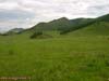
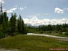
Typical landscape of medium- mountains with grass meadow steppes (foreground) and dark
coniferous forests (on the slopes). Clearly visible dependence of vegetation on the
exposure of slopes: the slopes of northern exposure (in the shadows) are covered with
coniferous forests, slopes of southern exposure (sunward) are covered with meadow steppes.
Height is about 1200 meters above sea level. Northwestern Altai, valley of the Elo river,
Ongudansky District, Altai Republic
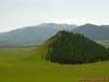
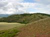
Tectonic outlier in the mountain hollow, occupied by the Elo River valley with
meadowsteppes. Conifer forests cover the slopes of northern exposure outlier. Height is
about 1200 meters above sea level. Northwestern Altai, Ongudansky District, Altai Republic
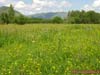
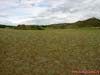
Grain meadow steppe on the slopes of southern exposure. Height is about 1200 meters
above sea level. Northwestern Altai, valley of the Elo river, Ongudansky District, Altai
Republic
High-altitude zone in the northwestern Altai: grass meadow steppe at elevations up to
1500 m are replaced by dark coniferous forests.Surroundings of village Elo, Ongudansky
District, Altai Republi
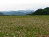
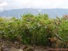
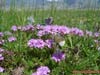
Middle-mountain forbs with legumes (Fabaceae): sainfoin (Onobrychis) and ranks
(Lathyrus) and grasses in the intermountain basin in northwest of Altai. Height is about
1000 meters above sea level, far away - Terektinsky ridge.Valley of the Karakol river,
Karakol Nature Park "Uch-Enmek", Ongudansky District, Altai Republic
Middle-mountain forbs with legumes (Fabaceae): sainfoin (Onobrychis) and ranks
(Lathyrus) and grasses in the intermountain basin in northwest of Altai. Height is about
1000 meters above sea level.Valley of the Karakol river, Karakol Nature Park
"Uch-Enmek", Ongudansky District, Altai Republic
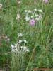
Edelweiss Siberian (Leontopodium palibinianum = Leontopodium sibiricum) in the midland
forb of meadow steppes. Height is about 1000 meters above sea level.Valley of the Karakol
river, Karakol Nature Park "Uch-Enmek", Ongudansky District, Altai Republic
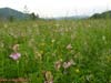
Middle-mountain forbs with Veronica, edelweiss and sainfoin in the intermountain basin
northwest of Altai. Height is about 1000 meters above sea level. Valley of the Karakol
river, Karakol Nature Park "Uch-Enmek", Ongudansky District, Altai Republic
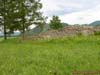
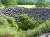
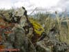
Middle-mountain cereal meadow steppe in the valley of Karakol. Pile of stones - one of
the excavated Bashadarsk mounds (Turkic culture VI-V centuries BC). Karakol Nature Park
"Uch-Enmek", Ongudansky District, Altai Republic
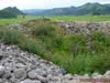
The central part of the excavated burial Bashadarsk mound (Turkic culture VI-V
centuries BC). Karakol Nature Park "Uch-Enmek", Ongudansky District, Altai
Republic
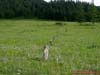
Stone women (idols), or Kezer tash in Karakol valley surrounded by grassmeadow steppe.
Karakol Nature Park "Uch-Enmek", Ongudansky District, Altai Republic
Rows of stone statues, or Kezer tash, leading to a small knoll surrounded by grass
meadow steppe. Tract of Lower Sooru, Karakol Nature Park "Uch-Enmek", Ongudansky
District, Altai Republic
Rows of stone statues, or Kezer tash, leading to a small knoll surrounded by grass
meadow steppe. Tract of Lower Sooru, Karakol Nature Park "Uch-Enmek", Ongudansky
District, Altai Republic
The central part of the excavated Bashadarsk burial mound (Turkic culture VI-V
centuries BC). Tract of Lower Sooru, Karakol Nature Park "Uch-Enmek", Ongudansky
District, Altai Republic
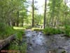
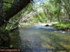
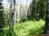
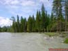
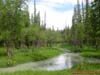
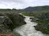
A small mountain stream, surrounded by light-coniferous (larch) forests. Tract of
Lower Sooru, Karakol Nature Park "Uch-Enmek", Ongudansky District, Altai
Republic
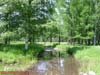
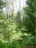
Mixed forests (with a predominance of birch and larch) in the floodplain of Karakol
river. Karakol Nature Park "Uch-Enmek", Ongudansky District, Altai Republic
Karakol river bed surrounded by riparian mixed forests (willow, birch, larch). Karakol
Nature Park "Uch-Enmek", Ongudansky District, Altai Republic
Floodplain motley grass with larches in Karakol Valley. Karakol Nature Park
"Uch-Enmek", Ongudansky District, Altai Republic
Floodplain forb meadows with domination of Lathyrus gmelinii (Lathyrus) in the Karakol
Valley. Karakol Nature Park "Uch-Enmek", Ongudansky District, Altai Republic
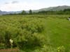
Karakol River floodplain with meadows, pastures and thickets of shrubby cinquefoil
(Kuril tea - Pentaphylloides fruticosa). Karakol Nature Park "Uch-Enmek",
Ongudansky District, Altai Republic
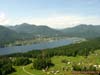
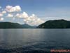
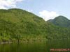
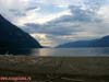
Lower reaches (lower, northern part) Teletskoje lake near the village of Iogach (left)
and Artybash (right), the source of the Biya river and the bridge across it, separating
the lake from the river. Turochaksky District, Altai Republic
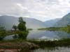
The northern part of Teletskoye lake in a tectonic basin surrounded by mountains
covered with dark-coniferous and mixed forests. Turochaksky District, Altai Republic
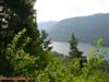
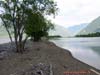
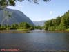
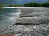
Biya River in the upper reaches, close to the source - Teletskoje lake, surrounded by
light coniferous forests (pine). Turochaksky District, Altai Republic
Biya River in the upper reaches, close to the source - Teletskoje lake, surrounded by
light coniferous forests (pine). Turochaksky District, Altai Republic
Mixed forest with predominance of aspen, spruce and fir on the shores of Teletskoye
lake (in the northern, lower part). Turochaksky District, Altai Republic
Mixed forest with predominance of aspen, spruce and fir on the shores of Teletskoye
lake (in the northern, lower part). Turochaksky District, Altai Republic
Mixed forest with predominance of aspen, spruce and fir on the shores of Teletskoye
lake (in the northern, lower part). Turochaksky District, Altai Republic
Meadow with grasses in a mixed forest with predominance of aspen, spruce and fir on
the shores of Teletskoye Lake (in the northern, lower part). Turochaksky District, Altai
Republic
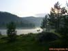
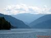
Teletskoe lake in a tectonic basin surrounded by mountains covered with
dark-coniferous and mixed forests. The middle part of the lake, Turochaksky District,
Altai Republic
Teletskoe lake in a tectonic basin surrounded by mountains covered with
dark-coniferous and mixed forests. The middle part of the lake, Turochaksky District,
Altai Republic
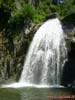
Korbu Falls (80 m) on the territory the Altai State Reserve. The middle part of the
Teletskoye lake, Turochaksky District, Altai Republic
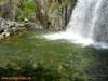
Classic Giants boiler of the Korbu Falls (80 m) on the territory the Altai State
Reserve. The middle part of the Teletskoye lake, Turochaksky District, Altai Republic
Teletskoe lake in a tectonic basin surrounded by mountains covered with
dark-coniferous and mixed forests. The middle part of the lake, Turochaksky District,
Altai Republic
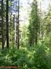
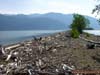
Sparse light-coniferous (larch) forests on steep slopes, southern (south-facing, and
therefore dry) exposure. Upper (southern) part of the Teletskoye lake, Ulagansky District,
Altai Republic
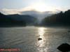
Oxbow lake at the mouth of the Chulyshman River. In the background - Chulyshman
Highlands (altitude peaks around 2000 m above sea level). Upper (southern) part of the
Teletskoye lake, Ulagansky District, Altai Republic
Sand spit (estuary bar) that separates the Chulyshman river oxbow from Teletskoje
lake. Cape Kyrsay in Kyginskiy Bay, Lake Teletskoye. Upper (southern) portion of the
Teletskoye lake, Ulagansky District, Altai Republic
Sand spit (estuary bar) that separates the Chulyshman river oxbow from Teletskoje
lake. Cape Kyrsay in Kyginskiy Bay, Lake Teletskoye.Upper (southern) portion of the
Teletskoye lake, Ulagansky District, Altai Republic
View of the Lake Teletskoe (north) with a sand spit (estuary bar) – Cape Kyrsay.
Upper (southern) portion of the Teletskoye lake, Ulagansky District, Altai Republic
View of the oxbow lake at the mouth of the river Chulyshman floodplain, covered with
small-leaved forests (willow, aspen) and Mount Tashtu (2033 m asl) on Chulyshman
Highlands. Upper (southern) portion of the Teletskoye lake, Ulagansky District, Altai
Republic
View of the oxbow lake at the mouth of the Chulyshman river valley, cutting Chulyshman
Highlands (altitude peaks around 2000 m above sea level). Upper (southern) portion of the
Teletskoye lake, Ulagansky District, Altai Republic
The valley of the Chulyshman river with rocky braids and floodplain, overgrown
small-leaved forests (willow, aspen). Chulyshman Highlands about 10 km from the mouth
(confluence to the lake), Ulagansky District, Altai Republic
Shaft near the river (weakly expressed) on the edge of the high floodplain Chulyshman
overgrown with birch (silver birch). Chulyshman highlands, the middle reaches of the
Chulyshman river, Ulagansky District, Altai Republic
Rocky (gravel) spit that separates the bed of Chulyshman River on the sleeves.
Chulyshman highlands, the middle reaches of the Chulyshman river, Ulagansky District,
Altai Republic
Erosion of the Chulyshman highlands slopes on the edge of the Chulyshman river valley.
The height of peaks around 2000 meters above sea level, the territory of the Altai State
Reserve, Ulagansky District, Altai Republic
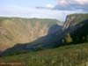
View of the Chulyshman river valley from the edge (cliff) of the Ulagansky plateau. On
the opposite side - Chulyshman Plateau and the Altai State Reserve. Ulagansky District,
Altai Republic
View of the Chulyshman river valley and its meandering channel from the edge (cliff)
of the Ulagansky plateau. On the opposite side - Chulyshman Plateau and the Altai State
Reserve. Ulagansky District, Altai Republic
View of the Chulyshman highlands edge and the Altai State Reserve from the cliff of
Ulagansky plateau. The height of peaks - 3000 m above sea level. At the bottom - the
valley of the Chulyshman river (average flow). Ulagansky District, Altai Republic
View of the Chulyshman river valley from the edge (cliff) of Ulagansky plateau. On the
opposite side - Chulyshman Plateau and the Altai State Reserve. Ulagansky District, Altai
Republic
View of the Chulyshman Plateau from Ulagansky highland, separated by Valley Chulyshman
discharge. Beyond - the territory of the Altai State Reserve with highest peak of about 3
thousand meters above sea level. Ulagansky District, Altai Republic
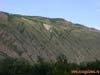
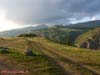
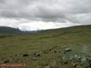
Mining cereal meadow steppe on the edge of Ulagansky plateau. Height - about 1600
meters above sea level. Ulagansky District, Altai Republic
Mining cereal meadow steppe with predominance of Feather Grass (Stipa pennata) on the
edge of the Ulagansky plateau. Height is about 1600 meters above sea level. Ulagansky
District, Altai Republic
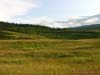
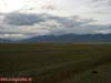
Geographical landscape of the Kurai steppe - the intermountain basin, which lies at an
altitude of 1500 meters above sea level between Kuraiskiy and North-Chui ridge and river
valley occupied by Chui. Dominated vegetation is desertified steppe and semi-shrubs dark
coniferous forests. Far away - North-Chui ridge. Kosh-Agach District, Altai Republic
Desertified semi-shrubs (small shrub with a long-term annual top the drying grass
parts) steppe in the Chui Valley. Kurai steppe, Kosh-Agach District, Altai Republic
Desertified semi-shrubs (small shrub with a long-term annual top the drying grass
parts) steppe in the Chui Valley. Kurai steppe, Kosh-Agach District, Altai Republic
Juniper elfin semi-shrubs in the desert steppe in the Chui Valley. Kurai steppe,
Kosh-Agach District, Altai Republic
Grain desert semi-shrubs steppe in the valley of the Chui river. Kurai steppe,
Kosh-Agach District, Altai Republic
Vegetative cover of desertified semi-shrubs steppes in the valley of the river Chui:
lichens, stonecrop, cereals and wormwood. Kurai steppe, Kosh-Agach District, Altai
Republic
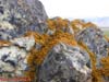
Orange lichen (Caloplaca murorum) on the rocks in the desert semi-shrubs steppe in
theChui Valley. Kurai steppe, Kosh-Agach District, Altai Republic
Meadows, pastures and dark coniferous forests (spruce) in the Chui Valley in the Kurai
steppe. In the background - North-Chui Range (highest peak 3000 m above sea level). Kurai
steppe, Kosh-Agach District, Altai Republic
Meadows, pastures and dark coniferous forests (spruce) in the Chui Valley in the Kurai
steppe. In the background - North-Chui Range (highest peak 3000 m above sea level). Kurai
steppe, Kosh-Agach District, Altai Republic
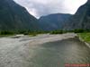
One of the branches of the river Chui surrounded by conifer forests. In the background
- the spurs of the North-Chui Range. Kurai steppe, Kosh-Agach District, Altai Republic
One of the branches of the river Chui surrounded by conifer forests. Kurai steppe,
Kosh-Agach District, Altai Republic
Floodplain mixed forest in the Chui Valley during the summer high water (water from
the main channel spreads over the surrounding woods). Kurai steppe, Kosh-Agach District,
Altai Republic
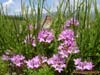
Thyme (Thymus altaicus) on the river Chui. Kurai steppe, Kosh-Agach District, Altai
Republic
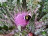
Bumblebee (Bombus sp.) on edible flower Thistle (Cirsium esculentum), Chui river.
Kurai steppe, Kosh-Agach District, Altai Republic
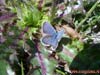
Silver-studded Blue (Plebejus argus) (males and females) on the flowers of thyme
(Thymus altaicus). Floodplain Chui river, Kurai steppe, Kosh-Agach District, Altai
Republic
Silver-studded Blue (Plebejus argus) in the male flowers of thyme (Thymus altaicus).
Floodplain Chui river, Kurai steppe, Kosh-Agach District, Altai Republic
Silver-studded Blue (Plebejus argus) male. Floodplain Chuiriver, Kurai steppe,
Kosh-Agach District, Altai Republic
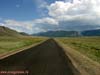
Chui Tract - Federal highway M-52, which connects Russia with Mongolia. Kurai steppe,
Kosh-Agach District, Altai Republic
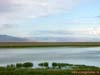
Freshwater lake in thermokarst depression formed by melting permafrost. Far away (70
km) - Sailugem ridge (the border with Mongolia). Chui (Chu) steppe, the left bank of the
Chui river, margin Kosh Agach, Altai Republic
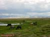
Grazing horses on the marsh lake in Chui (Chu) steppe. Away - spurs South-Chui Range.
The left bank of the river Chui, margin Kosh Agach, Altai Republic
Chui (Chu) steppe - desertified plateau in the intermountain basin at an altitude of
1800 meters above sea level, dominated by drought and salt tolerant vegetation on stony
grounds. Kosh-Agach District, Altai Republic
Dry mountain steppe at the foot of the South-Chu Range. The tract and the river valley
Elangash, near the village of Beltir destroyed by the earthquake of 2003. Kosh-Agach
District, Altai Republic
Elangash River in the foothills of South Chu Range. The tract and the river valley
Elangash, near the village of Beltir destroyed by the earthquake of 2003. Kosh-Agach
District, Altai Republic
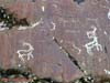
Rock paintings (petroglyphs) of the ancient (light) and Scythian (dark) ages on rocks
in the river valley Elangash. Kosh-Agach District, Altai
Republic
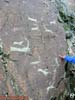
The famous "Scythian Deer" - rock paintings (petroglyphs) of the Scythian
period (VII-III centuries BC) in the Elangash river valley. Kosh-Agach District, Altai
Republic
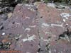
Rock paintings (petroglyphs) of the ancient (early AD) period on the rocks in the
Elangash river valley. Kosh-Agach District, Altai Republic
Rock paintings (petroglyphs), the ancient (early AD) period on the rocks in the
Elangash river valley. Kosh-Agach District, Altai Republic
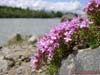
Alpine aster (Aster alpinus, family Asteraceae) in the mountain steppes in the
Elangash river valley (elevation is 2400 meters above sea level). South-Eastern Altai,
Kosh-Agach District, Altai Republic
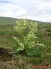
Wormwood tarragon, or tarragon (Artemisia dracunculus, Asteraceae family) in the
mountain steppes in the Elangash river valley (elevation is 2400 meters above sea level).
South-Eastern Altai, Kosh-Agach District, Altai Republic
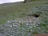
Burrow of grey or Altai marmot (Marmota baibacina) in the mountain steppes in the
Elangash river valley (elevation 2400 meters above sea level). South-Eastern Altai,
Kosh-Agach District, Altai Republic
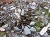
Litter of gray, or Altaic marmot (Marmota baibacina) in a mountain steppe in the
Elangash river valley. South-Eastern Altai, Kosh-Agach District, Altai Republic
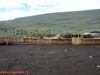
Fold (sheepfold), used in winter in the mountain steppes in the Elangash river valley.
South-Eastern Altai, Kosh-Agach District, Altai Republic
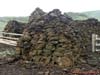
Blanks dung - dried sheep manure used as fuel and for building and repairing the shed.
Kosh-Agach District, Altai Republic
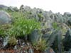
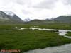
River Elangash upstream with herbaceous vegetation that grew during the period of
snowmelt in the mountains (elevation is 2400 meters above sea level). South-Eastern Altai,
Kosh-Agach District, Altai Republic
Pedicularis sp. in the Elangash river valley (upper reaches with elevation of 2400
meters above sea level). South-Eastern Altai, Kosh-Agach District, Altai Republic
Flowering rhubarb (Rheum sp.) in the mountain steppes in the Elangash river valley
(elevation is about 2400 meters above sea level). South-Eastern Altai, Kosh-Agach
District, Altai Republic
Elangash River upstream valley with herbaceous vegetation that grew during the period
of snowmelt in the mountains (elevation is about 2400 meters above sea level).
South-Eastern Altai, Kosh-Agach District, Altai Republic
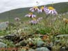
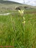
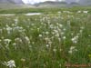
Alpine forb meadow steppe with an aspect of edelweiss Siberian (Leontopodium
palibinianum = Leontopodium sibiricum) in the upper reaches of the river Elangash
(elevation 2400 meters above sea level). South-Eastern Altai, Kosh-Agach District, Altai
Republic
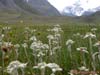
Edelweiss Siberian (Leontopodium palibinianum = Leontopodium sibiricum) in the high
meadow steppe grassland in the headwaters of the river Elangash (elevation 2400 meters
above sea level). South-Eastern Altai, Kosh-Agach District, Altai Republic
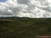
Fluvioglacial deposits of ancient glaciers at the mouth of the river Elangash valley
(output to Chui steppe). South-Eastern Altai, Kosh-Agach District, Altai Republic
From Photo Nature section of our site you can also download thousands images of fungi, lichens, plants and animals, made by professional Russian field biologists and geographers during their expeditions all over the Russia and former USSR republics. All objects from our collection are determined by scientist and have exact scientific name, date and place of taking picture, as well as size of the original image.
You are able to find necessary pictures using four different approach:
1) with a help of Geographic Index (all objects are separated by countries and nature geographical zones), 2) with a help of Systematic Index (all objects are separated by their systematic position),
3) with a help of Alphabetical Index (all objects are separated by their scientific Latin names according to the alphabet), and
4) with a help of Search Form (you can search scientific (Latin) names of species, genus, family, or order).
Our Field Ecology Center published more than
180 methodical materials for nature studies. Some of them are in English: